Brilliant Maps- Making Sense Of The World, One Map At A Time
כתבה מעיתון הארץ[]
איאן רייט מודה שגם הוא הופתע מההצלחה האדירה של הבלוג שלו ומן הפופולריות של האתר שהקים. הרעיון פשוט להפליא — רייט נובר ברשת ומוצא מפות שנוצרו בידי גיאוגרפים, חוקרים, מכוני מחקר, אוניברסיטאות, מגזינים ועיתונים כדי להבהיר באופן חזותי תופעה מעניינת. פשטות היא מלת המפתח. היכרות מפתיעה עם העולם שבו אנו חיים היא התוצאה הנדרשת
אין כמעט אבחנה בין נושאים "חשובים" ל"פחותי חשיבות". כל מה שמעניין קהל רחב ראוי לעיון והכי חשוב שמבט אחד מבהיר הכל. יש לרייט אינספור דוגמאות למפות כאלה — מפת עולם ובה עיגול די קטן שמקיף את סין, הודו ואינדונזיה מבהירה שבתוך העיגול חיים יותר אנשים מאשר בכל שאר העולם. מפה אחרת מדרגת בגוני אדום את הארצות באירופה שבהן הכי הרבה צעירים (עד גיל 35) גרים עם ההורים (סלובקיה מובילה עם 56 אחוז), מפה אחרת מראה איפה חיות הנשים הגבוהות בעולם (הולנד, דנמרק וסלובניה בראש הרשימה, בוליביה והפיליפינים בתחתיתה), איפה באירופה נולדים הכי הרבה ילדים מחוץ לנישואים? (איסלנד ואחריה החלק המזרחי של גרמניה, אסטוניה, שוודיה, נורבגיה וצרפת), או 22 המדינות שבהן לא צעד מעולם חייל בריטי (שוודיה, גואטמלה, חוף השנהב ועוד).
בין אימפריות[]
The Roman Empire vs. The Mongol Empire At Their Respective Peaks

The map above shows how big the Roman and Mongol Empires were at their respective peaks. The Mongols had the world’s largest contiguous land based Empire in history (and the second largest overall after the British), but just how much bigger was it than Rome?
Mongol Empire: 24 million km2 (9.27 million mi2), 17.81% of world land area in 1270 or 1309*
Roman Empire: 5.0 million km2 (1.93 million mi2), 3.71% of world land area in 117*
אתר דומה[]
The Dymaxion map or Fuller map is a projection of a world map onto the surface of an icosahedron, which can be unfolded and flattened to two dimensions. The flat map is heavily interrupted in order to preserve shapes and sizes.
The projection was invented by Buckminster Fuller. The March 1, 1943 edition of Life magazine included a photographic essay titled "Life Presents R. Buckminster Fuller's Dymaxion World". The article included several examples of its use together with a pull-out section that could be assembled as a "three-dimensional approximation of a globe or laid out as a flat map, with which the world may be fitted together and rearranged to illuminate special aspects of its geography."[1] Fuller applied for a patent in the United States in February 1944, the patent application showing a projection onto a cuboctahedron. The patent was issued in January 1946.[2]
The 1954 version published by Fuller, made with co-cartographer Shoji Sadao, the Airocean World Map, used a modified but mostly regular icosahedron as the base for the projection, which is the version most commonly referred to today. This version depicts the Earth's continents as "one island", or nearly contiguous land masses.
The Dymaxion projection is intended only for representations of the entire globe. It is not a gnomonic projection, whereby global data expands from the center point of a tangent facet outward to the edges. Instead, each triangle edge of the Dymaxion map matches the scale of a partial great circle on a corresponding globe, and other points within each facet shrink toward its middle, rather than enlarging to the peripheries.[3]
The name Dymaxion was applied by Fuller to several of his inventions.
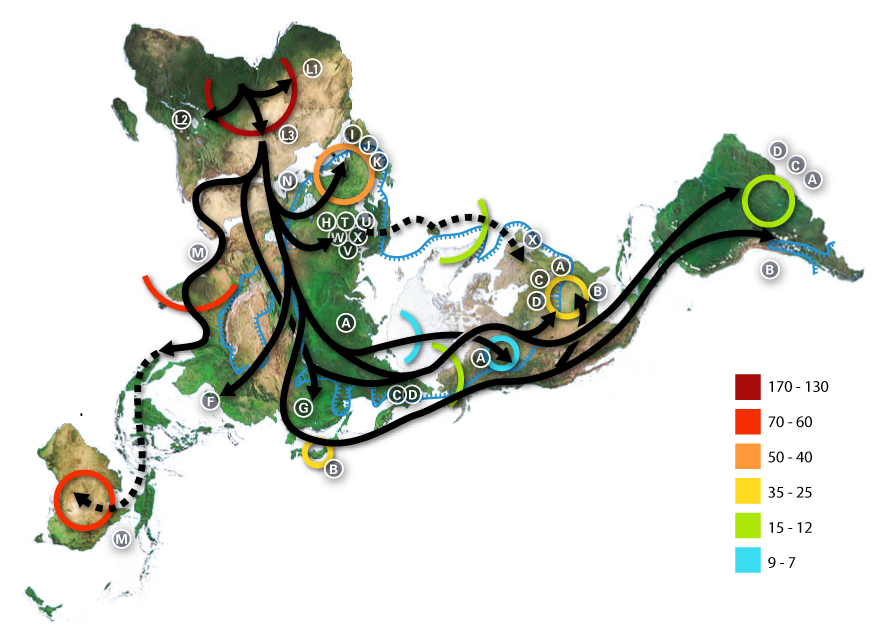
Example of use illustrating early human migrations according to mitochondrial population genetics (numbers are millennia before present)


